Showing posts with label Ottawa Valley. Show all posts

Thursday, June 18, 2026

From Main Street to the Back Forty: The Renfrew Subdivision (Part III)

In the first two posts about the former CN Renfrew Subdivision, I explored the rail line's creation as an important link between Western Canada and Eastern Canada. The line, as originally conceived, was meant to handle prairie grain at Depot Harbour on Georgian Bay and move it east. The same goes for timber harvested in Algonquin Park, which the railway's owner, John Rudolphus Booth, also controlled. In the 1930s, the line was severed in two in Algonquin Park, as a faulty bridge was never repaired. From that moment on, the rail line, now a CN concern, was a regional right-of-way with significantly less traffic.

Read Part I and Part II.

After that transcontinental resource and timber traffic died away, what were left were local freight and passenger services, linking the Upper Ottawa Valley with Ottawa. We traced the path of the CN Dayliner from Ottawa all the way to Barrys Bay in the first two posts. 


Through the years following the line being severed, the Renfrew Subdivision saw its share of interesting equipment, including the precursors of the Budd cars, the doodlebugs (as above). These units were meant to make marginal passenger lines more cost-efficient, but by the 1950s-1960s, the car was king and these passenger lines could barely hang on. 

In 1961, the passenger service was discontinued, as the line essentially became a marginal freight route. 

 
But, up until the discontinuation, you could ride the rails from Ottawa to Barrys Bay six days a week and back, except Sunday. There were even times when the passenger service came in the form of a full-fledged consist, with a steam engine, baggage car and coaches (all images in this post come from the Canada Science and Technology Museum Archives). 
 
As we explored in the first two posts, by the late 1950s and early 1960s, you could leave Ottawa's Union Station downtown at 4:30 p.m. and arrive in Barrys Bay at 7:30 p.m. via Budd car. If you were making your way to Ottawa from Barrys Bay, you would leave bright and early at 4:30 a.m. and arrive in Ottawa at 7:30 a.m., in time for some breakfast and the work day. 
 
However, the Renfrew Subdivision's story doesn't end in Barrys Bay, where regular passenger service ended. Up until the very end of passenger service in 1961, you could take a CN mixed train from Barrys Bay all the way to Whitney, which was the end of track after the line was severed in Algonquin Park. 
 
The mixed service ran Tuesday through Friday as 221 westbound to Whitney and 222 eastbound from Whitney to Barrys Bay. Since we took the train from Ottawa to the Bay in the first two posts, I thought it'd fun to take the mixed to Whitney in this post. There are very few passenger shots of the line past Barrys Bay, so we'll have to make do with what we found.
 
Barrys Bay Station - 9 a.m.
 
Given that the daily CN Dayliner arrived from Ottawa at 7:30 p.m., let's hope you found accommodations in town before getting ready for your morning departure west. This 1958 image, below, of a combine car, gives you an idea of what your accommodations would be on the mixed train west, near the end of service. 
 

From Barrys Bay, you'd be on the train for less than half an hour before coming to the first stop.
 
Aylen Lake flag stop - 9:20 a.m.
 
There are no images for this stop, which sits at the southern edge of part of Algonquin Park. It is listed as an access point for the park, so it makes sense that the railway would have service here at some point, if only for people looking to access cottages. 
 
From Aylen Lake, depending on if you stopped, you would make your way through the former flag stop of Opeongo, which is listed on the timetable, but without a time, which likely means it was no longer a stop.
 
Next up is a former division point and railway town, one that played a major role in the earliest days of the Ottawa, Arnprior & Parry Sound Railway. 
 
Madawaska Station - 10 a.m. 
 
A this point, you've been on the mixed train for an hour and have travelled 21 track miles or 35 kilometres. That means you've averaged about 35 km/h so far. This might be a result one of two factors. Either there were slow restrictions on this part of the line, or the mixed train might have to stop to pick up or drop off freight cars along the way. I can't imagine a lot of trackside business at this point, but you never know.
 
 
This is an image of the Madawaska Station in the 1940s, although it is not clear from the archives information when it was taken. The caption mentions that there was a railway restaurant in the station at this point. This all makes sense when you consider that Madawaska was once a service point for the railway, as evidenced by the roundhouse that once dominated the railway lands.
 

The text accompanying the images from the museum archives mentions the roundhouse was abandoned in 1933. This would make sense, as this was around the time when the line was severed, which would mean it was no longer a through route to Georgian Bay.
 

Here's another image that points to Madawaska's time as a railway servicing point. This image above is from the Grand Trunk era and is labelled as a coaling station. You can see the water tower in the background as well as a caboose. The photos tells a story of a town that once was quite prominent in the CN network.

Stay on the mixed train for another half hour and you get to the second last stop on the remaining subdivision.
 
L'Amable Station - 10:30 a.m.
 
At this point, you're about 30 track miles outside of Barrys Bay, in an area that, judging by the photos I found, is increasingly remote. This is the only image I could find of the L'Amable stop. The caption reads that the water tower was installed here when the tower in Madawaska was torn down. There is another shot of an earlier L'Amable train station on the Bancroft, Ontario website. According to this site, the community was popular with early settlers, who liked its fertile soils for farming. L'Amable is just south of Bancroft.
 
 
With this stop out of the way, you are now into the home stretch of CN territory in this part of the province. You are now headed to the end of the line.
 
Whitney Station - 11 a.m.
 
Half an hour after passing through L'Amable, you will arrive at Whitney, the end of the line for this subdivision. You can see that there are loaded cars, possibly full of agricultural goods. Off in the distance is a caboose as well. 
 
 
Again, the stations on this stretch of the line seem much more suited to cottage country. They do not follow the architecture of the stations closer to Ottawa. And while this rail line by the 1960s was a branch-line operation, there is some photographic evidence that the line still held an important purpose for local businesses and farmers.

 
This shot, above, is one of the first I found when researching this line. You can see a truck dumping farm products into a car on the right side of the image. This means that the subdivision was still very much a vital link for farmers and their markets in the 1950s and 1960s. You get the idea how much the transport of grains has changed by looking at this image. No hoppers or cylindrical Canada cars; just these cars, which are loaded from the top by dump trucks. 


If you needed to get back east from Whitney, you'd have to take the following day's mixed train back to Barrys Bay at 11:30 a.m., which would put you in the Bay at 1:30 p.m. In many ways, right up until the line was torn up all the way to Arnprior, the Renfrew Subdivision was a throwback in most respects. It served the small communities along its line for decades, until the business dried up. 
 
Today, these images, which were taken over the decades by Aubrey Mattingly, give us a clear picture of what life was like along the rails decades ago. We're incredibly lucky to have this time capsule available to see, which is not the case for many other forgotten rail lines across Canada. 
 
A special thanks to Eric Gagnon of Trackside Treasure for helping me figure out some aspects of the history of the rail lines in this part of the province in the 1960s. Between him, Steve Boyko of traingeek.ca and Kevin O'Neil, I was able to share some fascinating history for a forgotten stretch of track.  

Friday, May 29, 2026

From Main Street to the Back Forty: The Renfrew Subdivision (Part II)

In part I of this topic, I covered off the history of the Renfrew Subdivision trackage, which once extended from Ottawa all the way to Depot Harbour (Parry Sound) on Georgian Bay. The line, built by John Rudolphus Booth in the late 1800s, was a resource line at the beginning, carrying western grain from Georgian Bay and timber from Algonquin Park all the way to Montreal or Vermont, where Booth's railway lines (Canadian Atlantic) gave way to others. 

Over the years, the western grain shifted to Great Lakes freighters via the most recent Welland Canal and the timber in the park was exhausted. The line ceased to be a busy link in the transcontinental  network. The original Ottawa, Arnprior & Parry Sound Railway gave way to the Grand Trunk and finally the Canadian National. In more recent years, the line was cut back all the way to Arnprior and is now owned by Nylene Canada.

Undated photo of a freight train passing by South March (Kanata) along the Renfrew Subdivision. Photo from the Canada Science and Technology Museum online archives

But in 1959, CN still operated local service all the way to Whitney. West of Whitney, the line was severed in Algonquin Park. The western portion was then operated as a stub before it was shut down. As we outlined in the last post, you could still take a CN Dayliner all the way to Barrys Bay on the Renfrew Subdivision, although this service would not last much longer. It was discontinued in 1961.

We began our evening passenger ride from Union Station in downtown Ottawa, where CN's evening train left at 4:30 p.m. Here is what you could expect from this train.

Union Station - 4:30 p.m.

Bells Corners (flag stop) - 4:50 p.m.

South March (flag stop) - 4:58 p.m.

Carp Station - 5:08 p.m.

Kinburn Station - 5:19 p.m.

Galetta Station - 5:27 p.m.

At this point, we are leaving what was then known as Carleton County, later the Ottawa-Carleton Region, and what is now the City of Ottawa.

Once the train crosses over into Renfrew County, it will pass by the former flag stop of Marshalls Bay, which was listed on the CN schedule but without any service. At this point, the railway had already eliminated what it considered more marginal flag stops. The first stop after Carleton County would be Arnprior Station, one of the biggest towns on the line.

Arnprior Station - 5:35 p.m. 


This is a shot, also from the Canada Science and Technology Museum archives of the last CN Dayliner calling at Arnprior Station in 1961. You can see from the image that the Budd car is split in half with one part being for baggage and cargo and the other for passengers. There clearly was not much left in terms of demand. Still, from downtown Ottawa to Arnprior in an hour isn't all that bad. Try doing that by car on the Queensway-417 these days. According to the passenger schedule, the train has travelled 42 miles or about 68 kilometres. That means the train was averaging more than 70 km/h on the line, with station stops considered.

That brings us further west into Renfrew County, into the Upper Ottawa Valley, which once saw multiple train lines running through it (CN Beachburg, Renfrew subs and CP K&P, Chalk River subs). 

Glasgow Station - 5:48 p.m. 


What fascinates me about stops like Glasgow is how close they are to towns. Glasgow was less than six track miles from Arnpior, yet it still warranted a regular stop on the line. This tiny hut trackside is very much in the style of the South March Station, which we saw in the first post. Despite its rural locale, there are two tracks at Glasgow, suggesting there was a passing siding that was perhaps used for local freight delivery. You can see a large barn beyond the station. What I don't see is any road or parking lot next to the station. There looks to be a ramp from the building for a speeder to be eased onto the tracks.

Goshen (flag stop) - 5:55 p.m.

Just a few miles down the line, Goshen is listed as a flag stop station. There is no photographic record of what was trackside at milepost 53.4. but at this point, you would have been quite close to the actual town of Renfrew, so I'm thinking this was a minimal priority at best by 1959. 

Renfrew Station - 6:03 p.m.  

Next up is the town of Renfrew, one of the larger towns on the line. 

Renfrew was one of a few towns in the Upper Ottawa Valley that was served by two railways at one point. The town boasted not just a CN station, but a CP station as well. The CPR took over the former Kingston & Pembroke Railway, which terminated in Renfrew. Its Chalk River Subdivision once passed through town as well. This image above shows you what the Renfrew CN Station looked like 1972, 11 years after the last passenger train called at the depot. Unlike other stations on the line, Renfrew's seemed to have a more decorative turret on the roof instead of a squared off gable. 

It's interesting to note, as well, that CN also had facilities at what was known as Renfrew Junction. This image below showed its facilities at that junction. This building was demolished in 1957, so you wouldn't have seen it if you were taking the Dayliner in 1959.

Admaston Station - 6:15 p.m.

A few miles past Renfrew, you will reach Admaston, although no photos in the archive I check exist for this station. 

Douglas Station - 6:23 p.m.

A few miles past Admaston and you will hit Douglas Station. Here is an example of a station with different architecture compared to what we've seen so far. The platform is covered from beginning to end by a station-length eave. You can see a pallet at the end of the platform and a luggage cart. There's a piece of the community visible in the background to the right as well.


Caldwell Station - 6:28 p.m.

Three miles beyond Douglas brings you to Caldwell Station. There were no shortage of stops on this route for the Dayliner. There is no photographic evidence of what was trackside at this stop.

Eganville Station - 6:40 p.m.

Eight miles further west and you will come to another larger community on this line, Eganville, home to a well-known community newspaper, the Leader. Eganville has struggled in recent years, but the community was featured on the CBC Show Still Standing, where they profiled the community's efforts to keep going amid challenges. The photo below, also from the Canada Science and Technology Museum archives, shows you what the station looked like in the early 1970s, long after the last passenger train stopped at its platform.

 
Like other towns in the Ottawa Valley, Eganville once boasted a CPR station as well, when railways were building lines throughout the area in a competition to exploit the resources of the area. One reference to the CPR station stated that it was on the Eganville Subdivision, which terminated in the town. I had never heard of that old trackage before.
 
Golden Lake Station - 6:52 p.m.
 
We are beginning to near the end of our journey on the Dayliner. The next stop is the community with the picturesque name, Golden Lake. This shot, from the 1950s, shows you another example of somewhat unique architecture on the line. The station is a two-level structure without the angled roof and dormers that many of the stations on this line boasted. It looks more like a commercial building you'd find on a main street. There is a bay window jutting out onto the platform, where the station agent would have worked. The platform has two baggage carts. Off in the distance, you can see a boxcar set off on a siding.
 

Ruby (flag stop) - 7:00 p.m.
 
There is no photographic evidence of what was at this flag stop. But, again, it sounds quite nice, given its picturesque name.
 
Killaloe Station - 7:08 p.m.
 
Killaloe (pronounced Kill-a-LOO) is a name many people in Ottawa are familiar with, as this is a spot where many from the region escape to, as it is commonly known as cottage country in this part of the province. The community's station was very much consistent with other stations on the line closer to Ottawa. I would imagine that this area's status as a getaway was a source of passenger revenue for years for the Canadian National.
 

Simpson (former flag stop) 
 
At this point in the line's history, the Simpson flag stop is still listed on the schedule but there appears to be no service offered at this point, as the timetable does not even list a time.
 
Wilno Station - 7:20 p.m.
 
The second-last stop is Wilno, which is 105.7 track miles from Ottawa, or 170 kilometres. The station has a bit more of a rustic cottage-country look to it, which is in keeping with its location and surroundings. At this point, you've been on the train for nearly three hours and travelled nearly 200 kilometres. Not exactly a speedy ride.
 

Barrys Bay - 7:30 p.m.
 
Finally, you have reached the end of the line for this passenger run, 112 track miles or 180 kilometres from downtown Ottawa. Barrys Bay, unlike other communities on the line, has preserved its station and railway heritage. This is what the station looked like when you would have been taking the Dayliner. This photo was actually taken in the 1970s, after service ended. The station looked a bit rough, but the rail yard it still in place and the station looks like it is still ready to receive passengers or express cargo.
 

Now compare that to what the station looks like today, thanks to friend of the blog, Kevin, our eyes and ears in Windsor. Kevin was recently in Barrys Bay and shared these photos of the station and the adjacent water tower, which once served the railway.
 

The station looks great and has found new life as a restaurant in the community. 
 
 
I also like that the community preserved the CN sign on the water tower. It's the little things that make a difference.
 
There is more to the story of the old Renfrew Subdivision than this one train, which made its run between Ottawa and Barrys Bay six days a week (Sunday being the exception) as Train 689 and 690. I'll leave the additional service details for a third post, as the history of this line just keeps offering more for me to share and for us to discuss. I'll finish this post with another image from the Canada Science and Technology Museum archives of a CN special that made its way up the line into the Ottawa Valley in 1972. I would imagine that some of the 1970s photos in this post were captured by Aubrey Mattingly, who might have been aboard this special. It's incredible to me that so much history of this line was chronicled.
 

At one point, it seemed like every community in our vast country was either served by a train or was near a train line. Although much of the Renfrew Sub is a memory, we have lots of chronicled history to relive its glory days. One final post to come, which will chronicle another surprise.
 
Again, thanks to Steve Boyko of traingeek.ca and Kevin O'Neil for their help with this post. All photographs, except for the two modern Barrys Bay images, are taken from the Canada Museum of Science and Technology Archives  

Monday, May 18, 2026

From Main Street to the Back Forty: The Renfrew Subdivision (Part I)

To most railway enthusiasts in Ottawa and Eastern Ontario, what was once the CN Renfrew Subdivision is now technically Nylene Canada's Renfrew Spur. The track hosts one train a week, delivering tank cars of caprolactum to Nylene Canada's plant in Arnprior.

CN 589 crosses March Road in 2021 en route to Arnprior. The weekly train is the last vestige of a long history of operations on the former Renfrew Subdivision. Just to the right of the track is Station Street, where the old South March railway station once stood.

But what many people often forget is this lonely right-of-way was once one of the busiest railways in Canada. Yes, that's right. In all of Canada. 

Today, you'd hardly even be able to imagine it. Let's start briefly at the beginning. John Rudolphus Booth built a rail line from Depot Harbour*, on Georgian Bay, all the way to Ottawa, where it connected to Booth's other railway, the Canadian Atlantic. The two railways were soon joined under the CAR banner. The Ottawa, Arnprior & Parry Sound Railway began operations in 1897. 

(*- if Depot Harbour sounds unfamiliar, it's because Booth made the decision to establish his own port, away from Parry Sound, to foil the schemes of railway speculators in the town) 

Why was it the busiest rail line in Canada? Two reasons. Booth gained timber rights in Algonquin Park, which provided a great deal of traffic to his saw mill in Ottawa, not to mention to eastern U.S. markets via the CAR's terminus in Vermont. 

Secondly, Booth's OA&PS also shipped as much as 40 percent of the grain from the Canadian west to the St. Lawrence, as the fourth Welland Canal had yet to be completed. This meant that shipping grain via modern freighters on the Great Lakes was not yet possible due to the limitations of the smaller canals in the Welland area. The final Welland Canal was completed in 1932, which essentially replaced the Renfrew Subdivision's source of through grain from the Prairies.  

Booth's line was incredibly busy before this development, which is why it isn't surprising that the operations were acquired by the Grand Trunk in 1905. Of course, the boom years inevitably came to an end.

A Canadian National passenger train makes its way along the Renfrew Subdivision in the 1940s at an unknown location. Photo from the Canada Science and Technology collection.

The sharp downfall of the old Booth line happened mainly because of the grain movements shifting south to Welland, not to mention the fact that Booth had exhausted the useful timber in Algonquin Park, meaning the two main sources of through freight were gone. That meant that, by the 1930s, the Booth line had very much shifted to a secondary railway line under what was then the Canadian National Railways company, which bought the Grand Trunk in 1923.

It was a swift decline for a line that opened up vast stretches of Algonquin Park to tourists, considering it led to the creation of the Highland Inn and Cache Lake Station in the park. Many people forget that the Renfrew Subdivision was one of two major rail lines that crossed through the park, the other being the CN Northern Transcontinental Line. That line, the Beachburg Subdivision, went through what is now northwest Ottawa into the Pontiac Region in Quebec before crossing back into Renfrew County and all the way up to Pembroke, Petawawa and beyond.

The writing was on the wall for the Renfrew line as far back as 1933, when a trestle over Cache Lake/Lake of Two Rivers in Algonquin Park was closed due to safety concerns. That meant the line was cut in two and never reconnected. The western section between Depot Harbour/Parry Sound and Cache Lake was operated until 1952, when it was closed for good. The eastern section, terminating at Whitney, on the eastern edge of Algonquin Park, soldiered on as a local branch line for some time.

Fast forward to more recent times when most of the car load business dried up. For many years, CN tried to rid itself of the trackage, even when it was severed west of Arnprior. The line's final customer,  Nylene Canada (formerly BASF), still requires train service, as it cannot easily receive its needed product, caprolactum, by truck.

In the 1990s, there was talk of BASF being serviced by CP Rail's Chalk River Sub, which also reached up through Arnprior at one point. That connection was never made and the Chalk River Sub is history. In the end, a compromise was reached, which meant that the former Region of Ottawa-Carleton bought the land on which the tracks sit, while Nylene Canada bought the rails. That relieved CN of the obligation to maintain the line. 

When the Ottawa Central Railway took over CN's local operations in 1998, there was no longer any real threat to the Renfrew Sub. But when OCR sold back to CN in 2008, the same threat that has faced this line for decades resurfaced.

CN now serves Nylene on contract each week, essentially with running rights on an otherwise dormant line. This system seems to work, although CN has tried in recent years to remove itself entirely from Ottawa once again. Right now, its focus is mainly on customers east of the city. 

I'm skipping over decades of freight train history on this line, but it's not altogether that different from what you see on other marginal train lines. Without major freight customers, a branch line is not going to survive in today's highly centralized world of transcontinental railways. 

I figured we could relive some history and go on a trip from Ottawa to Whitney on the Renfrew Subdivision. 

Luckily for us, rail photographer Aubrey Mattingly was busy taking photographs of railways in the Ottawa area for decades. His collection passed into the hands of the Canada Science and Technology Museum. Many of his photos include everyday, somewhat mundane scenes that are now invaluable to us as we piece together the past. 

Let's start at the obvious place: Union Station in downtown Ottawa. This is what the old station looks like today, as the home of the Senate of Canada, which has been displaced from Parliament Hill due to construction of the Centre Block.

Thanks to some information supplied by Steve Boyko of traingeek.ca and Eric Gagnon of Trackside Treasure, I can pinpoint the final days of passenger rail service on the Renfrew Subdivision. CN ran its final trains on the line in 1961, but let's take the train in 1959, which is a significant year. It was the last year that many of the vestiges of the line's heyday remained.

UNION STATION: 4:30 p.m. departure 

Taking a Railiner (RDC or Budd Car in other words), you will leave Ottawa at 4:30 p.m.

This leads you to the first stop, which is the Bells Corners flag stop. It's important to note that, prior to the building of the Queensway, much of the land where the highway sits was the Renfrew Subdivision. After the National Capital Commission began lifting rail lines in the city under an expansive beautification effort in the 19502, the Renfrew Subdivision was largely scrapped from where it began all the way to Nepean Junction, where it branched off the Beachburg Subdivision.  

Sadly, there are no existing photographs of the Bells Corners station, but I imagine it would have been near Bells Junction, where the CN line met the CP Carleton Place Subdivision, which is also where there was once a flyover crossing. There is also a chance that the station was located west of here, near where Highway 416 is now. It's important to note that the 416 cut was obviously level ground in earlier days. 

Twenty minutes to get from downtown to Bells Corners? That seems slow by rail. There must have been serious speed restrictions. 

BELLS CORNERS flag stop: 4:50 p.m. 

SOUTH MARCH flag stop: 4:58 p.m.

This is the station that got me on the case of looking up the story of this rail line again. You might recall that I took a first crack at the history of this line in this post from 2019. I have often wondered what became of the Kanata train station, which was located on Station Street, just off of March Road, in the eastern part of the former city. My mistake was looking up Kanata Station in online searches. Needless to say, Kanata did not exist as a city until 1978, which I should have known.

Before Kanata was developed in earnest from farm land in the 1960s, it was mainly a rural township called March Township, hence the station's name, South March. The photo below is from the Canada Science and Technology Museum collection, as are all the remaining black and white images in this post.


This image was taken in 1958, shortly before CN demolished this building in 1959. That is why our 1959 trip west is so significant. It would have been the last time you could see all of these historic relics of the Renfrew Subdivision's past.

CARP STATION: 5:08 p.m.

This image, from 1944, is evidence of how important the railway was to small towns on this line. The Carp station seems quite large for a community so small. It's important to remember that, in the 1950s, the road network in this part of Ottawa was not nearly as developed as it is now. Same goes for many parts of Canada. Post-WWII, cars took over and the road network largely replaced short-distance passenger rail. Even in 1959, taking the train on this line would likely not have been a popular choice, as the operation was just a few years away from being discontinued.

This is where the history becomes fascinating to me. Many place names that are familiar to Ottawa residents but show no sign of their rail history, come alive, thanks to these images. Which brings us to our next stop.

KINBURN STATION: 5:19 p.m.

Note the similarity of the architecture of the stations on this line. It seems to me they were designed to provide accommodation to station agents and their families. It's hard for us now to understand the need for so many stations so close together.


This photo above was taken in 1959, again right before the station was demolished by CN. It's amazing that someone would think to capture images of so many stations in the 1950s. That brings us to our next stop, still in the western reaches of what is now Ottawa.

GALETTA STATION: 5:27 p.m.


You must be thinking that you're seeing double. The stations along this line were very much carbon copies of each other in many places, particularly in the smaller communities. You can see an old luggage cart on the platform of this station and the freight shed, for people who shipped goods via the railway express service.

At this point in the trip, you will be leaving what was then known as Carleton County, later the Region of Ottawa-Carleton (now Ottawa), so we will pick up our trip further east in the next post. You are by now an hour into your trip and you're not even out of Carleton County. This train is the definition of milk run!

This is an image from my map of the CN Rail system, back when the Renfrew Subdivision was still in place to the town of Renfrew in Renfrew County. After the train leaves what is now Ottawa, there are a few more surprise in store on the line. That will wait for the next post. 

Monday, January 20, 2025

An alternate history of rails in the Ottawa Valley

There is no shortage of lamentations online about the state of railways in the Ottawa Valley and loss of much-loved rail lines. The other day, I found myself in Bells Corners with a few minutes to spare, so I sat trackside, hoping to catch CN 589 on its way back from Arnprior. The train never showed, but I began to think of some documents I read years ago from the Canadian Transportation Agency about the Renfrew Spur, a long stretch of track, between the former Nepean Junction and Arnprior, that would be long gone by now if CN had its way. Strangely enough, you can thank the Canadian Pacific Railway (okay, CPKC if you want to get technical) for the survival of the former Renfrew Subdivision.

Long story short, in 1987, CN applied to discontinue service on what was then known as the Renfrew Subdivision because the railway claimed it lost more than $328,000 per year on the line. The reasons were pretty obvious. Its one main customer was Nylene Canada (formerly BASF), which required weekly service, mostly one to three tank cars of caprolactum from Texas. CN, in its filings to the CTA, said there weren't enough customers on the line to justify continued service. In 1987, there were less than 100 car movements on the line. Hardly worth the price of maintaining the tracks for a large railway.

Read the specific details of this line's status from my earlier post.

At the time, the Teamsters Union claimed that Sullivan's Lumber in Carp (later Rona) and a flour mill both wanted rail service, but nothing seemed to come of the union's claims.

Instead, there were discussions with both CN and CP over how Nylene Canada would continue to get rail service in a way that didn't cost a railway money. When you consider that the Renfrew trackage now runs roughly 50 kilometres from what was once Nepean Junction (where the Beachburg Sub once veered northwest toward Fitzroy Harbour and beyond) out to the Nylene plant, you understand that this is a lot of infrastructure to maintain for one eastern and western movement a week. 

At some point in these proceedings, it was decided that Nylene must have rail service, as the cost of shipping caprolactum by truck wasn't worth it for the company, which remains a major employer in Arnprior to this day. So the issue was how would the plant get served and which railway would provide the service in a way that was workable for everyone involved?

In 1987, Arnprior had both the Renfrew Subdivision and CP's Chalk River Subdivision running through the town. At the time, neither line could be described as a critical stretch of track, but CP did still use its Chalk River Sub for through freight, even if there was little to no trackside business. Also, Via Rail used the Chalk River Sub, as well as the CP Carleton Place Sub, for the Canadian, which once ran through Ottawa all the way to Montreal.

We all know how the story ends. We don't know what happened during this time between the government and the two railways, but we know the discussions over rail service to the Arnprior plant ended with the decision that CN would continue to serve the plant, instead of CP. But here's the question that I find intriguing. What if it was decided that CP would serve Nylene Canada?

If the Canadian Transportation Agency's discussions about rail service to Nylene Canada resulted in CP being the railway to provide the service, would there have been an Arnpior Turn originating in Smiths Falls? It might have happened.
 

Here are the possible scenarios that could have resulted from this decision, including my take on how likely they would be in a parallel universe.

1. CP would have retained part of the Chalk River Subdivision. (LIKELY) I think this could have been a likely scenario. Would the track have been owned by CP or would the land have been sold to local governments and the rails sold to Nylene? Possibly over time. But what makes this scenario less likely is the fact that, at the time the decision was made in 1987, the Chalk River Subdivision still hosted daily through freights as well as the Canadian. That's a far different situation than what CN was facing with the Renfrew Subdivision, which essentially hosted nothing but a weekly freight out to Arnprior and back. Possibly the Chalk River track would have remained a CP concern. 

2. CP would have retained the entire Chalk River Subdivision. (FAIRLY UNLIKELY) The other fascinating question would be if this weekly service, as mandated by the CTA, have caused CP to rethink its plans to abandon the Chalk River Sub in 2010-11? I ask this because possibly the weekly Arnprior service would have ensured that the subdivision between Smiths Falls and Arnprior remained in place. If that was the case, possibly Via Rail could have come in to maintain the remainder of the track to ensure the Canadian had its connection to Ottawa and beyond. And if that scenario seems possible, would it be a stretch for CP to keep running through freights on this line as a guest on a Via line? Or would the Ottawa Valley Railway still be involved on the sub? There are a lot of factors to consider here, but I think it might have happened.

The issue working against this possibility is that Via Rail did not have multiple trains using this line. Think about Via Rail's ownership of the old CN Smiths Falls Sub and the old CP Brockville Sub. These two lines see many movements a day, which makes sense for Via Rail to own and maintain them. The Chalk River Sub is not in the same league as these other lines. I think the entire track would likely not have made it.

3. CP would have retained the Carleton Place Subdivision. (UNLIKELY) This is where the alternate history gets a little murkier. Remember that Via Rail used the Carleton Place Sub and the Chalk River Sub as its route for the Canadian up until 1990. If CP had been forced to provide service to Arnprior, which would have necessitated a major stretch of the Chalk River Sub to be saved, would it mean that the Carleton Place Sub would have been saved? I don't think it would have saved this piece of track, which is but a memory now.

The reason I think this line was doomed no matter what was because it was essentially in the same situation as CN's Renfrew Subdivision, with no freight activity. In its final days, it was hosting Via Rail and nothing else. The discontinuance documents show the line had two car loads in and out in 1986 and nothing else afterward. This document from 1988 shows that CP was essentially losing anywhere from $250,000 to nearly $500,000 a year on this stretch of track, even though Via and officials from Carleton Place wanted the line kept in place. Notice from the document that the former Region of Ottawa-Carleton did not take a position on the rail line, but asked for the right of first refusal to buy the land.

My guess is that the Canadian, if it still had access to the Chalk River Sub and was running through to Montreal, would have gone to Smiths Falls and switched onto the old CN Smiths Falls Sub, where it could then continue on its way to Ottawa and then Montreal. It's fascinating to consider that train stopping at Fallowfield Station.

Is the platform at Fallowfield long enough for the Canadian? It's interesting to consider.
 
4. CN would have torn up the Renfrew Subdivision (SURE THING) There's no doubt at all that the Renfrew Sub would have been a goner had the CTA decision on rail service to Arnprior been different. Most likely, the land would have either been converted to a trail or sold off in parts of the city where it could be developed, like in Kanata. As it stands today, the line is still in place, with a 10 mph speed limit, giving you an idea of the condition of the rails. 

The final factor to consider in this alternate history is the fact that CPKC now has a transcontinental link across Canada re-established. Given that CP can run trains all the way out to port in New Brunswick, possibly there could have been consideration to keeping the Chalk River Sub in place or at least re-establishing a connection between Chalk River and Arnprior, if that part of the line saw a discontinuance even with the CP service to Nylene.
 
Of course, in the early 1990s, no one could have foreseen CP relinquishing its cross-Canada network only to reacquire it years later, but it's fascinating to think what might be possible if CP had been mandated to serving Nylene in Arnprior.

Wednesday, June 15, 2022

Let's begin at the end

I'm old enough to remember when freight trains had cabooses at the end. I remember, in fact, the union campaign, Trains are safer with a caboose. Of course, the march of progress was unstoppable and the caboose went the way of the dodo on many railways in the 1980s. CSX maintained them on the Sarnia Subdivision until the early 1990s, which was cool for me when I watched trains when younger.

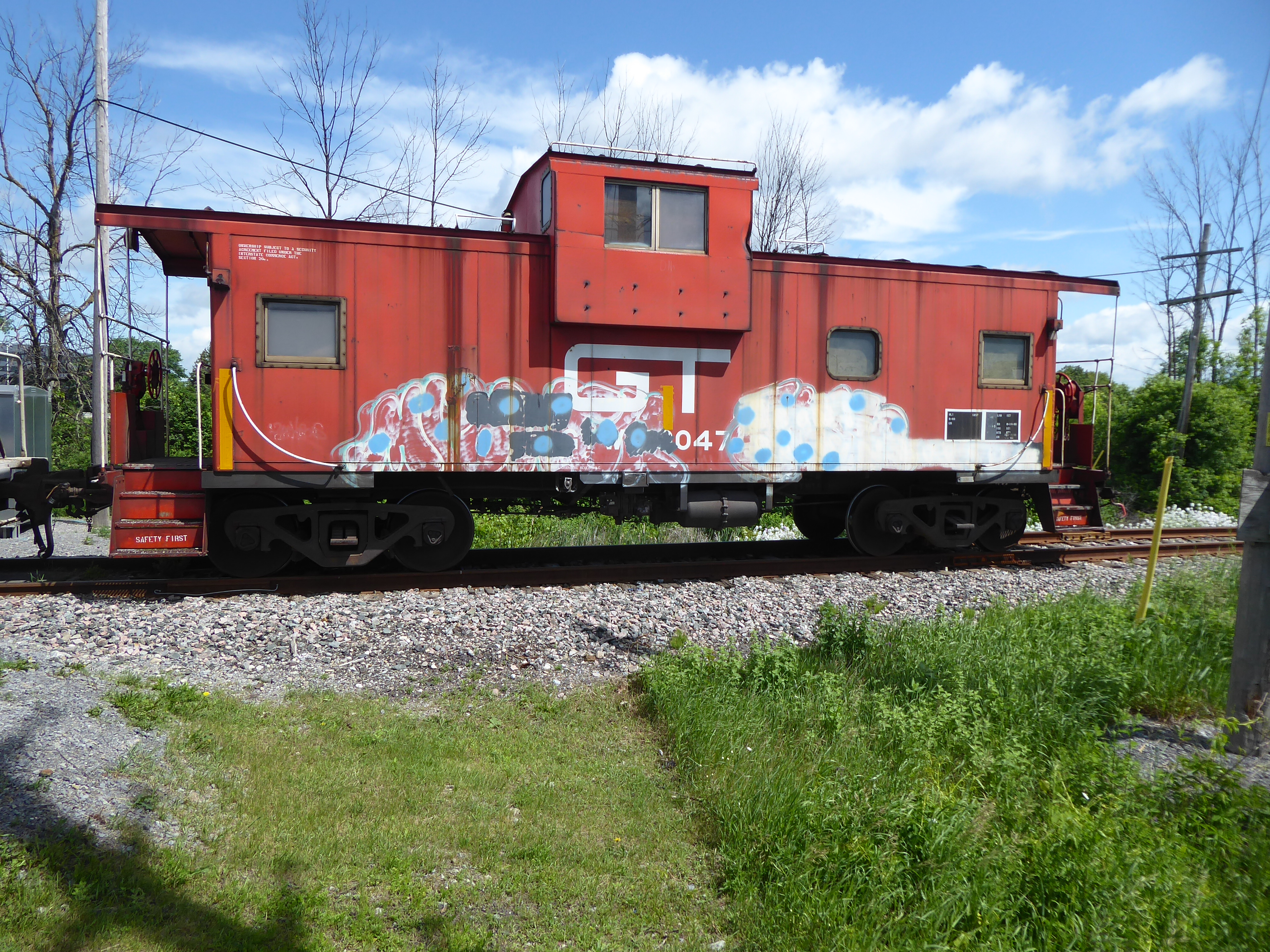
So imagine my surprise on June 8 when I heard the Arnprior Turn (CN 589) making its way through my neighbourhood and I decided to follow it, only to see this at the end. It was a GTW 79047 caboose still in its original scheme. Of course, there was no crew in the cupola, or even in the caboose. The car is clearly being used for shoving moves, giving the conductor a safe platform to watch the tracks ahead.

Of course, this isn't the first time CN has made use of an old caboose in its Ottawa operations. CN has made use of an former Devco caboose and the famous Millennium caboose in past years. Walkley Yard even hosted an old CN caboose hitched to an old RDC unit, both of which were owned by a company in Toronto and patched DAWX.

Over the course of my wanderings trackside, I did see CN using the infamous Millennium caboose once when it was shunting cars in Walkley Yard. I just managed to get this shot from the end of Albion Road on public property.

I will get into the history of CN's cabooses in its Ottawa operations in my next post, but for now, let's just admire the fact that the railway has used more than one caboose locally over the course of the last 10 years. It's an anomoly for sure, but not unexpected, given that there is a significant amount of shoving operations that the railway needs to perform in this area.

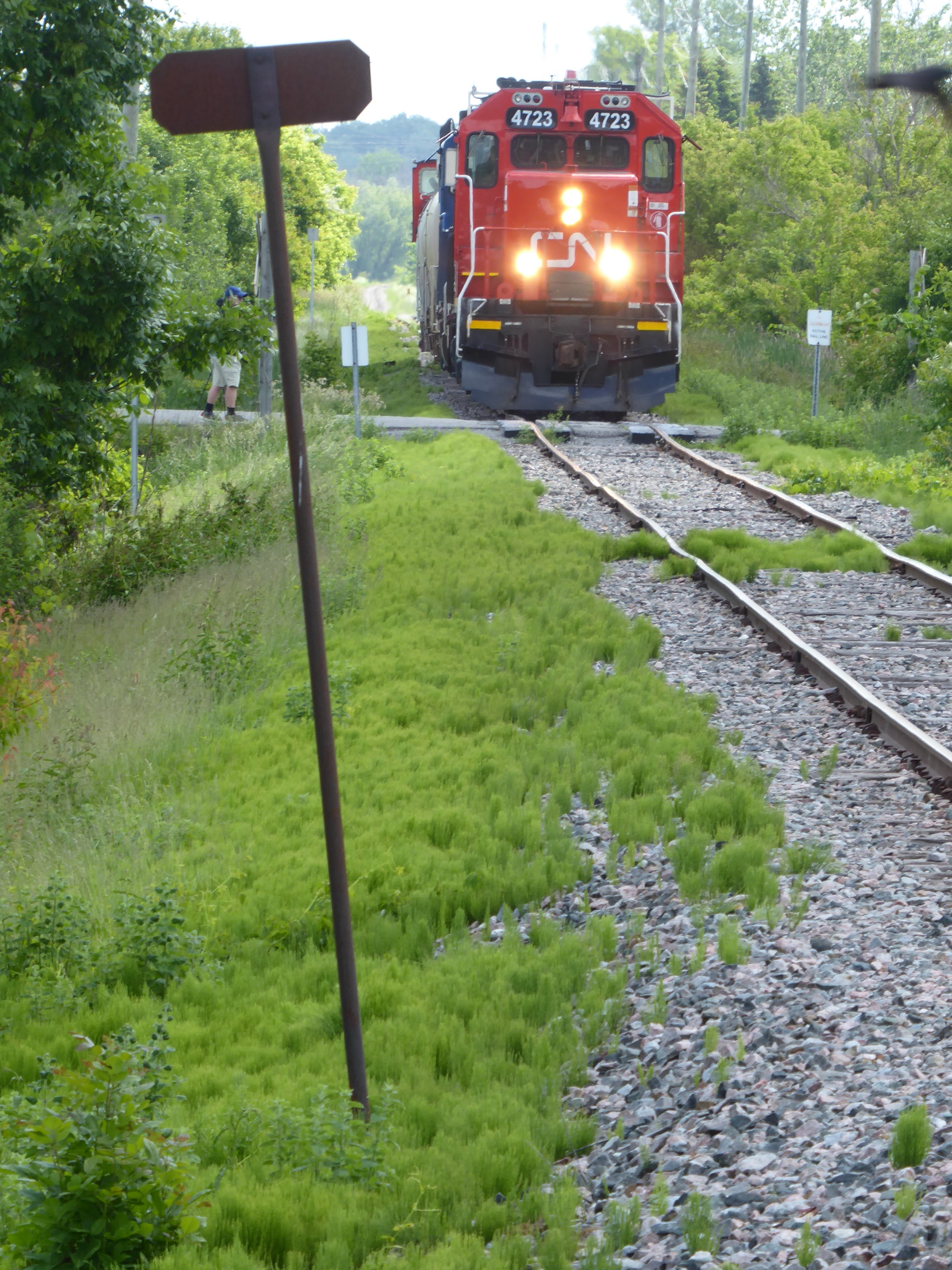
On June 8, I would not have caught up to the train if not for the fact that the crew stopped at a private crossing before March Road to grab a coffee at Tim Hortons, which sits trackside along the Renfrew Spur. That allowed me to park near the Tims and get some shots from March Road, like this head-on shot, which is not possible usually. The skies washed out on this shot, given the angle of the sun but I did manage to frame the trackside sign. You can just make out a railfan to the left of the shot. He had a camera set up on a tripod on the private crossing, which is blocked to vehicles.

Right when the train was easing to a stop, I took a quick photo of the two units from across Carling Avenue. I noticed the GATX unit doesn't seem to be a leased unit anymore. It's patched CN 4905, which suggests to me that the unit is now CN property.


As the train slowly made its way toward March Road, I tried to get some shots of the overall consist, which featured four tank cars loaded with caprolactum and the GT caboose bringing up the rear.

CN continues to use two GP38s on its run to Arnprior, including the GATX unit, which has been a common site in Eastern Ontario for the last several years. The March Road crossing offers a fairly unobstructed view of the Renfrew Spur right-of-way, although you do have to position your shots around a few guy wires and trackside poles. But at least the crossing gives you clearance against the trackside shrubbery, which can ruin your shots.

This is a shot of the March Road crossing, which gives you a better shot of the GATX unit. This is the first time I have captured anything at this crossing. Now that I know what I'm facing here, I will definitely come back, if the chance presents itself.

Even though I was on the sunny side of the train, this side of the caboose was not nearly as photogenic as the other side, which sat in the shadows. There was no graffiti on the other side, while this side was pretty marked up. 

Not knowing if I would ever see this old relic again, I tried to get it from as many angles as I could, including this profile shot, which gives you a view of the entire train as it makes its way slowly east toward the Huntmar crossing and eventually, Arnprior.

One final shot as the train made its way west. I don't take a lot of vertical shots but I took quite a few this past week, which made for some interesting shots. All in all, it was a lucky meet, as I decided at the last minute to chase this train on my break from work and caught it only because of its unscheduled stop near March Road.

It was quite a week for the Arnprior Turn, as it was featured in a story on CTV Ottawa's local newscast. The message that Nylene Canada was delivering was nothing new. There's 40 kilometres of track that the company owns that is being used by one customer. The company would obviously like to see more customers use rail service. It's a great idea in theory, but as readers of this blog know, Nylene has made this pitch before to the Ottawa Sun. I mentioned that story, which was behind a paywall, in this blog entry from 2014.  

I guess I'm skeptical that this latest pitch will get anywhere, since CN is a reluctant service provider in this case, as it is mandated to provide this service to Nylene. If CN does indeed pull out of Ottawa, as it has publicly stated that it wants to do, who steps in? All of the publicity in the world won't help if there is no railway company to provide the service.

Monday, February 13, 2017

Almonte: A town proud of its rail heritage

This post is the first in a rail history series I intend to extend through 2017 as we celebrate Canada's 150th birthday.

It's been six years since Canadian Pacific trains have thundered through Almonte, Ontario, a picturesque town just southwest of Ottawa in Lanark County. The town, which is now known as a haven for tech entrepreneurs, has been a railway town since before Confederation. Having been settled in 1818, due to the Mississippi River rapids that powered several mills, Almonte was first served by the Brockville and Ottawa Railway. In 1864, the railway opened an extension between Almonte and Arnprior, which connected the Grand Trunk in Brockville with the timber concerns in the Ottawa Valley, all the way up to the Ottawa River at Sand Point.

Over the years, Almonte's numerous mills, many of them involved in textiles, were served by the B&O and its successors. That was because the B&O quickly ran into financial trouble when it extended its line to Arnprior. The Canada Central was given the rights to build rail further up the Ottawa Valley, which it did. By 1881, the Canada Central reached Mattawa, which would form an important part of the backbone for the Canadian Pacific transcontinental mainline. CP purchased the CCR in 1881, which essentially established railway service for Almonte for the next 120 plus years.


This shot, above, is one of the earliest photos I could find of the railway in Almonte. Amazingly, this scene would not change much over the next hundred plus years, as much of the town's 19th century buildings were preserved, This image, from Library and Archives Canada, is undated, but would likely date back to the early 1900s or the turn of the century. The only information listed on the photograph states that the train is passing a flour mill on the Mississippi River.

Unfortunately, Almonte's railway history is best known for a horrific crash that happened on Dec. 27, 1942. On that day, in bad weather, a troop train bringing soldiers from the Canadian West slammed into the back of a local, which was carrying passengers from various Ottawa Valley towns to Ottawa for the evening. The crash killed 30 people, all in the local. A number of factors were blamed for the crash, but the largest cause was that the railway had no official in Pakenham to stop the troop train, which was gaining on the local. If the troop train had been stopped for 20 minutes, the crash would have been prevented.


This shot, from the National Archives, shows the aftermath of the crash. There is a plaque near the site of the crash in Almonte, which honours the 39 people killed and remembers the bravery of local residents and soldiers in the troop train, who worked to help 150 people who were injured in the crash.

Almonte's rail history sadly no longer includes the old Canadian Pacific station. It's unfortunate that the station didn't get saved, given how much of the town's 1800s-era stone structures have been faithfully preserved.

However, you need only look at the rail bridge over the Mississippi River today to see what impact the railway had on this town.


This shot, above, is from the Canada Science and Technology Museum archives. I would say this shot is probably from the early to mid 1980s, given the prominence of the large multimark on two of the three units and the yellow reefer boxcar.

This shot, above, also gives you an idea of the importance of the rail line that went through Almonte. The Chalk River Subdivision was a strategic line for CP for years, as it gave the railway a connection between its northern main line in eastern Canada with its more southerly main line, which in Eastern Ontario is the Winchester Subdivision. Just like CN had with the Beachburg Subdivision, CP used the Chalk River Sub as its northern main line through the Ottawa Valley.


But, just like the Beachburg Sub, the Chalk River Sub was soon deemed too expensive to operate, since most of CP's traffic to Montreal was concentrated through its southern route through Toronto. This made the northern main line rails through the Ottawa Valley obsolete (see also the CP Prescott Subdivision).

In 1996, the Ottawa Valley Railway began operating on trackage between Sudbury and Smiths Falls after leasing the lines from CP. The arrangement meant that freight from the west still travelled over CP's northern route, as CP was a major source of carloads for OVR. That arrangement worked well for OVR until 2009, when CP stopped using this northern route for its eastbound freight, which cut the carloads for OVR from 4000 to 1000 (OVR, which is now a Genesee &Wyoming concern, continues to operate between Sudbury and Temiscaming, Quebec)

An interesting side note to this abandonment is that CFB Petawawa is no longer served by rail. At one point, the military base used both CP and CN (later the Ottawa Central) for delivery of some of its equipment. This made for some pretty interesting movements.

By the end of 2009, OVR's parent railway bailed out on operations in the Ottawa Valley and CP proceeded to start the process of abandoning the Chalk River Sub. Municipalities fought to save the line, none more so than Mississippi Mills, the municipality that includes Almonte. Those efforts failed, as is often the case, and all that is left of the Chalk River Sub now are memories and, in some spots, a recreational trail. This is what has been happening in Almonte, as efforts have been made to develop this section of the old rail line into a trail. Lanark County has leased the old rail line from CP and has recently begun the process to buy the old right-of-way. Meetings were held in January to update the public on how this trail will take shape.

1956 scene from Almonte's old railway station

On a personal note, I am happy to say that I was lucky enough to see trains roll through Almonte a few years ago. The sight of freights rumbling over the Mississippi River is one of the best moments you would have had as a railfan in Eastern Ontario.


Now, all you can do is relive the experience via YouTube. This is one of many railfanning videos you will find at the EasternOntarioTracks YouTube channel, which I highly recommend if you are looking for a nice variety of railway action in this part of the province.